Showing posts with label Winter 2008. Show all posts

Tuesday, July 29, 2008

Frost on July 11

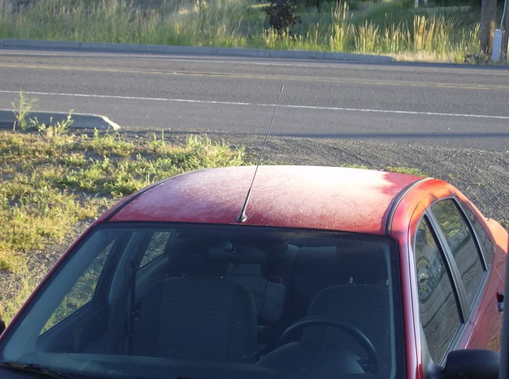
Palousitics contributor Mattwi finally sent along these pictures of his car on the morning of July 11, 2008.


As you can see, the temperature in Colton that morning was 33 degrees Fahrenheit.
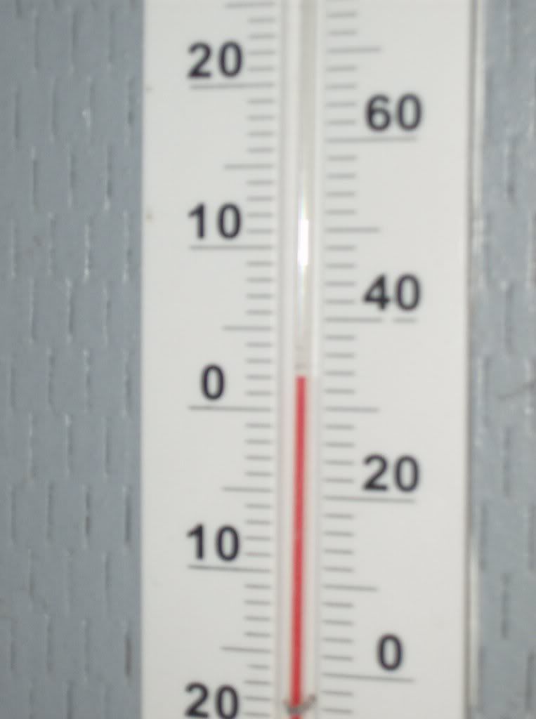

The official low temperature at Pullman-Moscow Regional Airport was 35 degrees, a record low for July 11. The following morning saw record lows as well. The Whitman County Gazette reported that the 33 degrees temperature at the airport was the lowest ever for July 12. The Gazette reported that crops and gradens were damaged by the unprecedented late freeze.

The ravages of global warming continue on the Palouse.

Friday, June 20, 2008

North to Alaska

A Palousitics reader writes: "After your late winter snow, we are getting your refugees here in Alaska." Notice the personalized license plate on the truck and the sticker on the back of the camper top.

Wednesday, June 11, 2008

Global Warming Quote of the Day

Greg Koch, a forecaster at the National Weather Service in Spokane, said Pullman received 1.5 inches of snow [on June 10], which is the latest snowfall on record dating back to 1940, when weather records were first kept. It also was the first time measurable snowfall was recorded in the month of June.
-"'Crazy' snowfall causes problems in Pullman," Moscow-Pullman Daily News, June 11, 2008


Tuesday, June 10, 2008

Yep, It's The Year Without a Summer

As of 9:00 AM PDT, there is 1/2 inch of snow on the ground in Pullman and it is still falling hard.

Paging Mr. Al Gore, please pick up the white Frosty the Snowman courtesy phone....

UPDATE AT 10:00 AM PDT: Just got a call from home. About one inch of now there now. My daughter, who lives with her mom in South Carolina, is enjoying her "summer" vacation from school here in Pullman.


Monday, June 9, 2008

The Year Without a Summer?

My daughter, who recently moved from Virginia to Pullman, asked me the other day, "When is it going to get warm?"

According to an article in Sunday's Seattle Times, not until July...maybe.

Meanwhile, in today's Seattle Times, it is reported that:
Seattle just experienced the coldest first week of June, according to climate records dating to 1891, said Cliff Mass, University of Washington meterologist. Both 1999 and 2008 share the record, with 1917 falling in second place, he said. "Just wait until tomorrow," he said, when temperatures are going to be even colder.

<-snip->

"In 30 years I can only remember two other times when it snowed this late in the season," said Sam Krahenbuhl, Snoqualmie Pass assistant maintenance superintendent. "One time it snowed on a Fourth of July weekend. This is really rare."

While it won't snow in the Puget Sound area, records for the lowest high temperature may be broken today and Tuesday. Forecasters said the high temperature today should be 57 degrees, 1 degree below the record set last year. On Tuesday, under windy and rainy skies, the temperature should only get to 54 degrees, 2 degrees below the record set in 1972.
Mountains in Eastern Washington and Northern Idaho are also expected to see snow above 3,500 feet.

Remember, there's only 7 years, 7 months and 19 days until the The Goracle predicts the Earth will melt......

Friday, June 6, 2008

Headed Over to Western Washington This Weekend?

Might want to carry chains.

Summer starts in two weeks.

From the National Weather Service:
SPECIAL WEATHER STATEMENT
NATIONAL WEATHER SERVICE SEATTLE WA
430 AM PDT FRI JUN 6 2008

WAZ513-518-519-062230-
OLYMPICS-WEST SLOPES NORTHERN CASCADES AND PASSES- WEST SLOPES CENTRAL CASCADES AND PASSES- 430 AM PDT FRI JUN 6 2008

...A STRONG LOW PRESSURE SYSTEM WILL BRING SIGNIFICANT SNOWFALL TO THE HIGHER ELEVATIONS OF THE CASCADES AND OLYMPICS TODAY..

RAIN AND SNOW WILL INCREASE OVER THE MOUNTAINS OF WESTERN WASHINGTON THIS MORNING...BECOMING HEAVY AT TIMES THROUGH THE DAY. THE MAIN SNOW LEVEL WILL HOVER NEAR 3500 FEET BUT TEMPERATURES WILL BE MARGINAL FOR ACCUMULATING SNOW BETWEEN 4000 AND 5500 FEET. THE HEAVIEST PRECIPITATION IS EXPECTED LATER THIS MORNING AND AFTERNOON WHEN UP TO 3 INCHES OF SNOW COULD FALL AT THE HIGHER PASSES. ABOVE 5500 FEET...COLDER TEMPERATURES WILL ALLOW ALL THE FALLING SNOW TO STICK WITH UP TO 2 FEET EXPECTED BY THIS EVENING. THIS WILL RESULT IN A HAZARD FOR MOUNTAINEERING AND TRAVEL IN THE HIGH BACKCOUNTRY WITH POOR VISIBILITY...WINDY CONDITIONS...COLD TEMPERATURES...AND THE POSSIBILITY OF RENEWED AVALANCHE ACTIVITY.

PEOPLE DRIVING OVER THE HIGHER HIGHWAYS INCLUDING STEVENS PASS..CHINOOK PASS...WASHINGTON PASS...THE ROAD TO PARADISE...AND THE ROAD TO HURRICANE RIDGE...WILL LIKELY ENCOUNTER SNOW...POOR VISIBILITY...AND SOME WIND. HOWEVER ACCUMULATIONS ON THE ROADS WILLGENERALLY BE THREE INCHES OR LESS.

Friday, April 18, 2008

Wake Up and Schuss the Powder

From today's Seattle Times:
The last time Seattle-area residents contended with snow this late in the season was more than three decades ago, when Seattle-Tacoma International Airport reported snow on April 17, 1972, said Johnny Burg, a meteorologist with the National Weather Service.

[...]

"We've had powdery snow practically the whole season," said Duncan Howat, general manager at Mount Baker. "This is a great end for what's already been a record season for us."

[...]

Years ago, Mount Baker used to operate well into May — and even went until July 4 once during the 1970s, Howat said. But now its season concludes in late April, ending this year on April 27.
Eastern Washington will also be faced with snowy conditions this weekend.

It's interesting to note that the last time we had a winter this bad was in the Seventies. It was almost 33 years ago exactly, April 28, 1975, that Newsweek ran a story titled "The Cooling World."

Notice the graph in the Newsweek article of average temperature change from 1880 to 1970. It's a classic sine wave. Since then, the average temperature change swung back up again, peaking in 1998. It has remained stable since then, declining slightly. Could we be at the beginning of another downturn in temperature like in the Seventies? Who knows? The weather and climate are constantly changing. The only thing that is consistent is man's alarm and overreaction at the various trends.


One thing that does not exhibit sinusoid behavior is the amount of global carbon dioxide emissions from fossil fules. It is steadily increasing. The level of atmospheric CO2 is now nearly twice that in the Seventies. But we still have a winter like this one? I'm skeptical that one climatological phenomenon (La Nina) could override all that CO2 if that truly was causing the planet to warm so dramatically.

Wednesday, April 16, 2008

Snow Job

The Seattle Times does have a way with the words. First, they refer to terrorists as "ecosaboteurs."

Now, in keeping with the precepts of the Holy Gospel of the Boiling Planet, the Slimes calls our recent winter (which is still not over) "unusual" with an "extraordinary amount of snow." In fact,
Because of the unusual winter, the Legislature appropriated another $5.25 million over the $35 million budget. That leaves a $3 million deficit that will be carried into next winter. State officials are hoping a lighter-than-normal winter could make up some of those costs.
Huh.

Meanwhile,
In Washington state, a new climate change law calls for reducing vehicle miles by 18 percent by 2020, 30 percent by 2035 and 50 percent by 2050, starting from a statewide baseline of 75 billion miles per year.
Go figure.

Sunday, April 6, 2008

In Case You Were Wondering

That snow yesterday pushed this winter up higher on the all-time snowiest list. From the National Weather Service:
AS OF 1 AM SUNDAY APRIL 6TH...THE WINTER SNOWFALL TOTAL FOR SPOKANE WAS 89.4 INCHES. THIS TOTAL IS THE SECOND SNOWIEST ON RECORD. RECORDS HAVE BEEN KEPT FOR SPOKANE SINCE 1893.
Not many people alive have seen a winter this snowy, as the last one was in 1949-50. Of course, the NWS was quick to point out:
2007-2008 SEASON NOT YET COMPLETE. MORE SNOW IS POSSIBLE.

Tuesday, April 1, 2008

Winter 2007-08: Fifth Snowiest Ever

All the snowy weather over the past few days has pushed the winter of 2007-08 to fifth place on the all-time snowfall list for Spokane, with a seasonal total of 82.4 inches.

Here's how this winter stacks up:

93.5" 1949-50
89.0" 1974-75
87.3" 1992-93
83.2" 1955-56
82.4" 2007-08

We were only one or two good storms away from 2007-08 being the snowiest winter ever in the Inland Northwest.

Thursday, March 27, 2008

Bad Timing or Bad Karma?


The Palouse-Clearwater Environmental Institute's "Focus the Nation" climate change panel discussion and screening of the film, "Revolution Green: A True Story of Biodiesel in America," scheduled for January 31 in Moscow was cancelled after a blizzard dumped 14 inches of snow.

So they must have figured that rescheduling it for March 27, one full week into spring, would be safe, right?

Wrong.


A strong spring snowstorm blew through the Palouse overnight. There is 5 inches of the white powdery stuff here at Forbicite HQ. Moscow schools are closed. Pullman schools are two hours late. U.S. 195 is closed between Pullman and Colton. No word yet on the "climate change" event.